Florida Memory is administered by the Florida Department of State, Division of Library and Information Services, Bureau of Archives and Records Management. The digitized records on Florida Memory come from the collections of the State Archives of Florida and the special collections of the State Library of Florida.

State Archives of Florida
- ArchivesFlorida.com
- State Archives Online Catalog
- ArchivesFlorida.com
- ArchivesFlorida.com
State Library of Florida
Related Sites

Description of previous item
Description of next item

Source
Description
Date
Contributors
Format
Coverage
Personal Subjects
Subjects
Geographic Term
Note to Researchers:
Though the WPA field workers included extensive citations for the factual information contained in these county histories, it should be noted that these historical narratives were produced in the 1930s by federal government employees, and might reflect the inherent social biases of the era.
Title
Subject
Description
Creator
Source
Date
Contributor
Format
Language
Type
Identifier
Coverage
Thumbnail
Geographic Term
Display Date
ImageID
Subject - Person
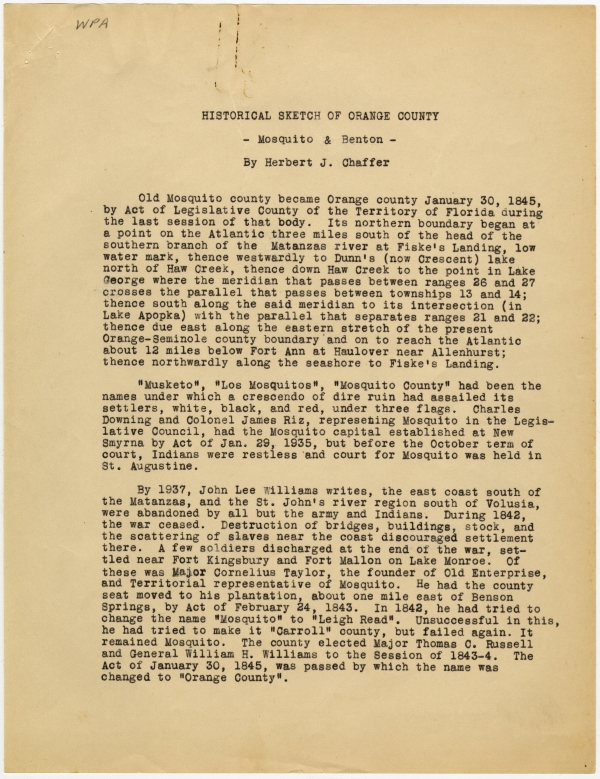
Transcript
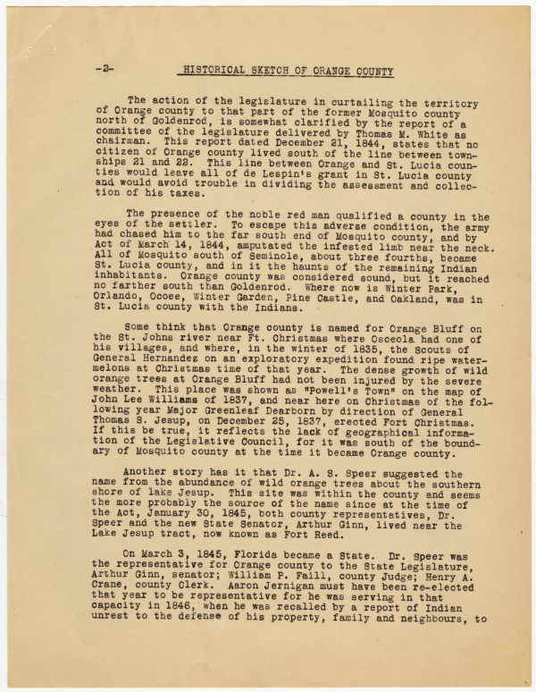
-2- HISTORICAL SKETCH OF ORANGE COUNTY
The action of the legislature in curtailing the territory of Orange county to that part of the former Mosquito county north of Goldenrod, is somewhat clarified by the report of a committee of the legislature delivered by Thomas M. White as chairman. This report dated December 21, 1844, states that no citizen of Orange county lived south of the line between townships 21 and 22. This line between Orange and St. Lucia counties would leave all of de Lespin’s grant in St. Lucia county and would avoid trouble in dividing the assessment and collection of his taxes.
The presence of the noble red man qualified a county in the eyes of the settler. To escape this adverse condition, the army had chased him to the far south end of Mosquito county, and by Act of March 14, 1844, amputated the infested limb near the neck. All of Mosquito south of Seminole, about three fourths, became St. Lucia county, and in it the haunts of the remaining Indian inhabitants. Orange county was considered sound, but it reached no farther south than Goldenrod. Where now is Winter Park, Orlando, Ocoee, Winter Garden, Pine Castle, and Oakland, was in St. Lucia county with the Indians.
Some think that Orange county is named for Orange Bluff on the St. Johns river near Ft. Christmas where Osceola had one of his villages, and where, in the winter of 1835, the Scouts of General Hernandez on an exploratory expedition found ripe watermelons at Christmas time of that year. The dense growth of wild orange trees at Orange Bluff had not been injured by the severe weather. This place was shown as “Powell’s Town” on the map of John Lee Williams of 1837, and near here on Christmas of the following year Major Greenleaf Dearborn by direction of General Thomas S. Jesup, on December 25, 1837, erected Fort Christmas. If this be true, it reflects the lack of geographical information of the Legislative Council, for it was south of the boundary of Mosquito county at the time it became Orange county.
Another story has it that Dr. A. S. Speer suggested the name from the abundance of wild orange trees about the southern shore of lake Jesup. This site was within the county and seems the more probably the source of the name since at the time of the Act, January 30, 1845, both county representatives, Dr. Speer and the new State Senator, Arthur Ginn, lived near the Lake Jesup tract, now known as Fort Reed.
On March 3, 1845, Florida became a State. Dr. Speer was the representative for Orange county to the State Legislature, Arthur Ginn, senator; William P. Faill, county Judge; Henry A. Crane, county Clerk. Aaron Jernigan must have been re-elected that year to be representative for he was serving in that capacity in 1846, when he was recalled by a report of Indian unrest to the defense of his property, family and neighbours, to
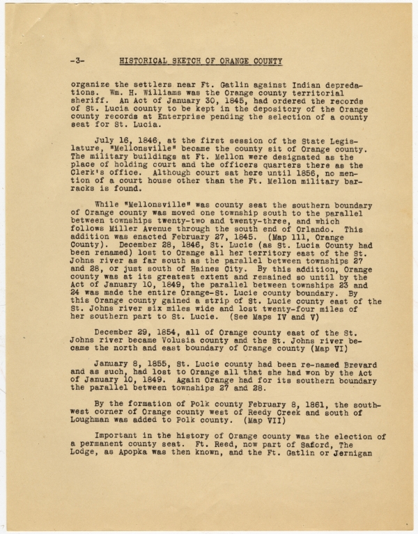
-3- HISTORICAL SKETCH OF ORANGE COUNTY
organize the settlers near Ft. Gatlin against Indian depredations. Wm. H. Williams was the Orange county territorial sheriff. An Act of January 30, 1845, had ordered the records of St. Lucia county to be kept in the depository of the Orange county records at Enterprise pending the selection of a county seat for St. Lucia.
July 16, 1846, at the first session of the State Legislature, “Mellonsville” became the county [seat] of Orange county. The military buildings at Ft. Mellon were designated as the place of holding court and the officers quarters there as the Clerk’s office. Although court sat here until 1856, no mention of a court house other than the Ft. Mellon military barracks is found.
While “Mellonsville” was county seat the southern boundary of Orange county was moved one township south to the parallel between townships twenty-two and twenty-three, and which follows Miller Avenue through the south end of Orlando. This addition was enacted February 27, 1845. (Map lll, Orange County). December 28, 1846, St. Lucie (as St. Lucia County had been renamed) lost to Orange all her territory east of the St. Johns river as far south as the parallel between townships 27 and 28, or just south of Haines City. By this addition, Orange county was at its greatest extent and remained so until by the Act of January 10, 1849, the parallel between townships 23 and 24 was made the entire Orange-St. Lucie county boundary. By this Orange county gained a strip of St. Lucie county east of the St. Johns river six miles wide and lost twenty-four miles of her southern part to St. Lucie. (See Maps IV and V)
December 29, 1854, all of Orange county east of the St. Johns river became Volusia county and the St. Johns river became the north and east boundary of Orange county (Map VI)
January 8, 1855, St. Lucie county had been re-named Brevard and as such, had lost to Orange all that she had won by the Act of January 10, 1849. Again Orange had for its southern boundary the parallel between townships 27 and 28.
By the formation of Polk county February 8, 1861, the southwest corner of Orange county west of Reedy Creek and south of Loughman was added to Polk county. (Map VII)
Important in the history of Orange county was the election of a permanent county seat. Ft. Reed, now part of [Sanford,] The Lodge, as Apopka was then known, and the Ft. Gatlin or Jernigan
-4- HISTORICAL SKETCH OF ORANGE COUNTY
settlements were the candidates. James Speer, representative of Orange county to the State legislature, took advantage of a recent ruling of the Federal government that allowed soldiers on duty to vote wherever they were posted and had a garrison placed in Ft. Gatlin before the election was held. With the added votes secured by this action, the neighborhood about Ft. Gatlin won the election and the spot was named Orlando. By Act of the State Legislature December 20, 1856, Orlando became the county seat.
By Act of February 14, 1872, Orange county received that part of [Sumter] county’s territory east of the Ocklawaha river. By this change that part of the southern boundary of Marion county which lies east of the Ocklawaha river as far as the town of Altoona became part of Orange county’s northern boundary. Eustis, Emeralda, Umatilla, Ft. Mason, Lisbon and Grand Island are now in this addition. (Map VIII)
Orange county lost to Brevard and Polk counties by the Act of February 18, 1873, a strip of land 12 miles wide but, excepting the waters of Lake Tohopekaliga a line east and west through the northern limits of St. Cloud became its southern boundary. By an Act passed the next day the waters of Lakes Tohopekaliga and East Tohopekaliga north of the line dividing townships 25 and 26 were added to Orange county, (Map IX) and by Section III of the same Act, Orange county gained from Brevard county that portion of townships 26 and 27 west of Lake Tohopekaliga and the Kissimmee river and east of Polk county (Map IX)
A slight change was made by the Act of March 5, 1879, by which the Polk-Orange county line was more definitely described, but little change was effected in territory.
May 12, 1887, Orange county territory south of the parallel dividing townships 24 and 25 went into the newly formed Osceola county, and Orange county assumed her present southern boundary. (Map X)
May 27, 1887, Lake county was formed. Orange county contributed to Lake county the territory added from [Sumter] county by Act of February 18, 1872, and gave up to Lake county the sites of Eustis, Umatilla, Emeralda and Ft. Mason. The Lake-Orange county line became the Meridian between ranges 26 and 27. (Map XL)
Seminole county was formed from Orange county April 25, 1913. The parallel between Townships 21 and 22 and the Wekiva river forming the chief Orange-Seminole county boundary lines (Map XII)
By Herbert J. Chaffer
ORANGE COUNTY
Among the many interesting items of the history of Orange County that have been brought to light by the Historical Records and State Archives Surveys is the odd fact that the first representative to the State legislature did not live in the county nor did the greater part of the citizens who elected him, in fact for several years very little of our Orange county was in the original tract of that name, although the settlers of this neighborhood were unaware of the fact.
St. Lucia county created by act of March 14, 1844, removed from old Mosquito county all its territory south of the township line between townships 21 and 22, and with it all of Orange south of parallel through Goldenrod. Although the meridian between ranges 26 and 27 (through Lake Apopka) and that between townships 36 and 37 (through Fort Ann at the Haul-over), had been run by Colonel Henry Washington, the United States surveyor, the unsettled condition of the Indians had obviated his traversing the county line of St. Lucia county and settlers near Ft. Gatlin as well as their representative, through themselves in Orange county.
Aaron Jernigan was the first and last territorial representative from the Orlando neighborhood. As the member from Orange county, he was re-elected in 1845. He was recalled in 1846, from his legislative duties at Tallahassee to protect his herds and family. By that time Florida had become a State, but during these two years, the fort Gatlin settlement and Captain Jernigan’s stockaded homestead were in St. Lucia county. By the Act of December 28, 1846, the Orange-St. Lucia county boundary was moved far enough south that Ft. Gatlin became part of Orange county, and Jernigan became an inhabitant of the county he represented.
Even the maps compiled by the United States and furnished in 1847, to the counties of Florida gave Orange county the lines by which Mosquito had been bounded prior to the foundation of St. Lucia county, March 14, 1844.
Chicago Manual of Style
Works Progress Administration, Historical Records Survey. Historical Sketch of Orange County. 1939 (circa). State Archives of Florida, Florida Memory. <https://www.floridamemory.com/items/show/321143>, accessed 24 December 2025.
MLA
Works Progress Administration, Historical Records Survey. Historical Sketch of Orange County. 1939 (circa). State Archives of Florida, Florida Memory. Accessed 24 Dec. 2025.<https://www.floridamemory.com/items/show/321143>
AP Style Photo Citation
(State Archives of Florida/Works Progress Administration)

 Listen: The Assorted Selections Program


