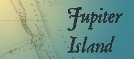
This map shows land granted to Gomez by the Spanish government in the early 19th century. The grant included all of modern day Jupiter Island, from the St. Lucie River to the Jupiter Inlet.
Florida Memory is administered by the Florida Department of State, Division of Library and Information Services, Bureau of Archives and Records Management. The digitized records on Florida Memory come from the collections of the State Archives of Florida and the special collections of the State Library of Florida.

State Archives of Florida
- ArchivesFlorida.com
- State Archives Online Catalog
- ArchivesFlorida.com
- ArchivesFlorida.com
State Library of Florida
Related Sites
Florida Maps: Then & Now
Florida Maps: Then & Now is an animated map series from the State Library and Archives of Florida. The project uses Google Earth to create animated videos using historic and modern maps, photographs, and primary source documents from our collections.
Jupiter Island
Wacahoota
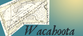
Florida's cattle industry is the oldest in what is now the United States. Native American immigrants, later known as Seminoles, migrated into the area and began working the former Spanish livestock.
Jacksonville
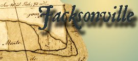
Long before concrete and steel spanned the St. Johns River near downtown Jacksonville, the Timucuan chief Saturiwa (Sat-ur-e-ba [IPA: Sæt-ur-ih-bah]) presided over the area shown on this map, from the confirmed Spanish Land Grant of Ezekiel Hudnall. This Westward bend in the St. Johns sits upstream from the French built Fort Caroline, destroyed and then rebuilt by the Spanish and christened Fort San Mateo in the 1560s.
Ft. Lauderdale
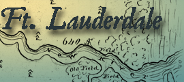
Lounging green Iguanas, discarded pets imported from another land, bake in the sun, contrasting against the white limestone rocks along the New River in modern downtown Fort Lauderdale. This map, from the confirmed Spanish Land Grant of Lewis Frankee, shows the area at a much earlier time, when the winding river was frequented only intermittently by Seminole Indians and shipwreck victims.
Matanzas River
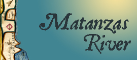
This map, drawn by surveyor Robert McHardy, shows the confirmed Spanish Land Grant of Joseph M. Hernandez along the Matanzas River, a plantation he dubbed "Mala Compra." The river along the bottom, or West, edge of the map derives its name from events that took place at a nearby inlet in 1565, when Spaniards under the command of Pedro Menendez de Aviles massacred French Huguenots associated with the Fort Caroline settlement.
Key Biscayne
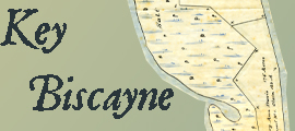
Key Biscayne is a long barrier island that sits just offshore of metropolitan Miami. This map, from the confirmed Spanish Land Grant of Mary Ann Davis, shows Key Biscayne long before dredging altered its shoreline, and causeways linked it to the mainland.
Features
Historical Records
Territorial Legislative Council Records, 1822-1845
Documenting Florida's legislature prior to statehood
Historical Records
State and County Officer Directories, 1868-1969
Lists of Florida's state and county officials either elected or appointed between 1868 and 1969.
Research Tool
Guide to Military Records and the Wartime Experience
A guide to government records and manuscript collections relating to service members and the wartime experience.
Playlist
Dust Tracks
21 tracks from Hurston's time documenting African American culture for the WPA in 1930s Florida.
Classroom
History Day 2025
Resources for Florida History Day from the State Library and Archives of Florida.