Florida Memory is administered by the Florida Department of State, Division of Library and Information Services, Bureau of Archives and Records Management. The digitized records on Florida Memory come from the collections of the State Archives of Florida and the special collections of the State Library of Florida.

State Archives of Florida
- ArchivesFlorida.com
- State Archives Online Catalog
- ArchivesFlorida.com
- ArchivesFlorida.com
State Library of Florida
Related Sites
Description of previous item
Description of next item
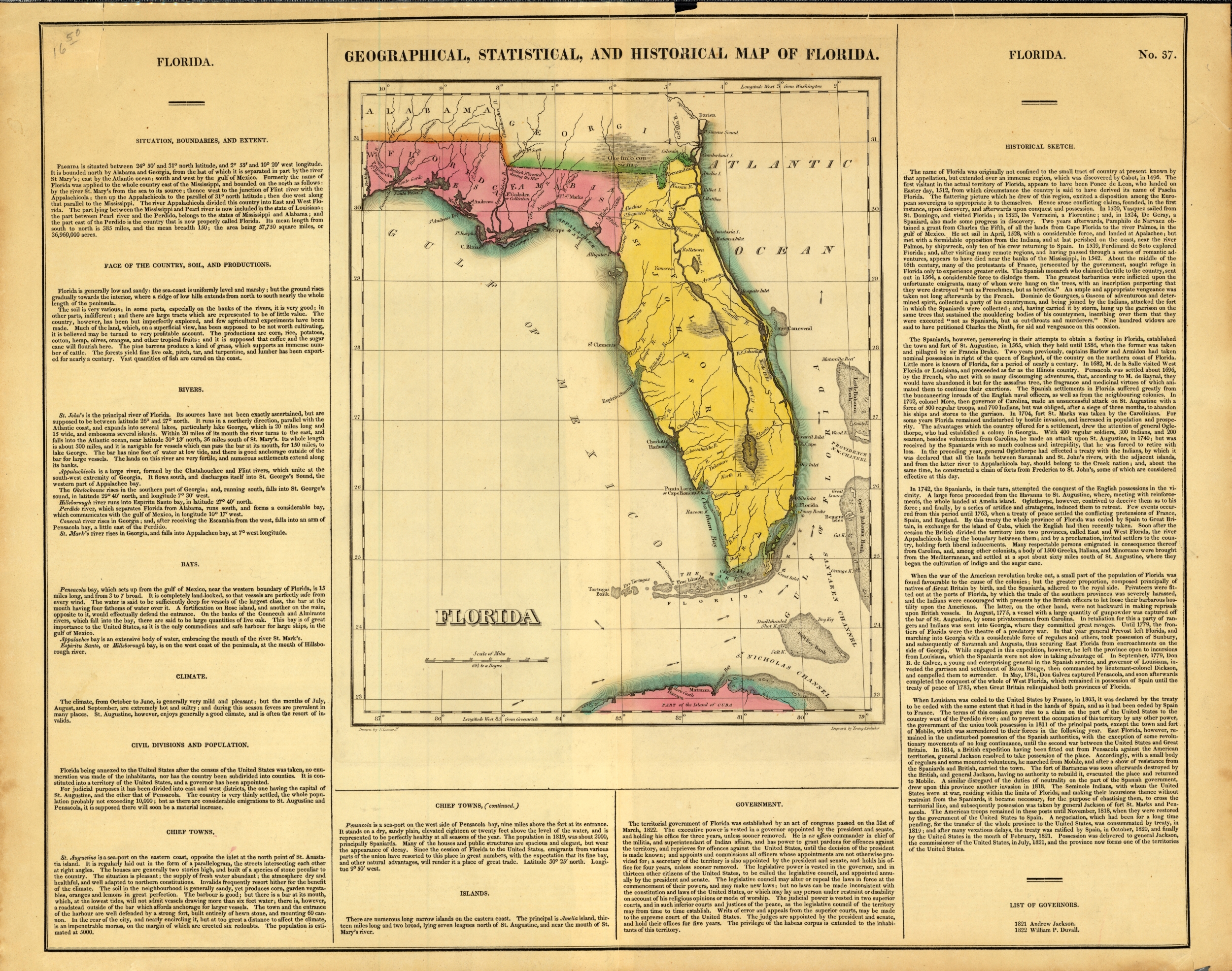
Lucas's Florida, 1822
Geographical, statistical, and historical map of Florida
Title
Lucas's Florida, 1822
Map Number
fmc0225
Source
State Library of Florida, Florida Map Collection, HISTORIC ERA 19TH CENTURY 0024
Date
1822
Creator
Additional Creator
Publisher
[c.1822]
Physical Description
1 map : hand-colored; 30 x 24 cm., on sheet 42 x 58 cm.
Scale
Scale [1:3,801,600. 1 in. to 60 miles]. (W 10°10'00"--W 1°50'00"/N 31°40'00"--N 23°00'00")
General Notes
Drawn by F. Lucas, Jr. ; engraved by Young & Delleker.
Prime meridians: Washington, D.C. and Greenwich.
Hand colored.
Map surrounded by text.
No. 37.
Prime meridians: Washington, D.C. and Greenwich.
Hand colored.
Map surrounded by text.
No. 37.
Coverage
Geographic Scope
Format
Subjects
Counties (69)
Alachua County
Baker County
Bay County
Bradford County
Brevard County
Broward County
Calhoun County
Charlotte County
Citrus County
Clay County
Collier County
Columbia County
Dade County
DeSoto County
Dixie County
Duval County
Escambia County
Flagler County
Franklin County
Gadsden County
Gilchrist County
Glades County
Gulf County
Hamilton County
Hardee County
Hendry County
Hernando County
Highlands County
Hillsborough County
Holmes County
Indian River County
Jackson County
Jefferson County
Lafayette County
Lake County
Lee County
Leon County
Levy County
Liberty County
Madison County
Manatee County
Marion County
Martin County
Miami-Dade County
Monroe County
Nassau County
New River County
Okaloosa County
Okeechobee County
Orange County
Osceola County
Palm Beach County
Pasco County
Pinellas County
Polk County
Putnam County
Santa Rosa County
Sarasota County
Seminole County
St. Johns County
St. Lucie County
Sumter County
Suwannee County
Taylor County
Union County
Volusia County
Wakulla County
Walton County
Washington County
Related Maps


Lucas's Florida, 1822
Order Prints
Please select the size and options
Order Scan
High Resolution Scan - $20.00