Florida Memory is administered by the Florida Department of State, Division of Library and Information Services, Bureau of Archives and Records Management. The digitized records on Florida Memory come from the collections of the State Archives of Florida and the special collections of the State Library of Florida.

State Archives of Florida
- ArchivesFlorida.com
- State Archives Online Catalog
- ArchivesFlorida.com
- ArchivesFlorida.com
State Library of Florida
Related Sites

Description of previous item
Description of next item

Source
State Archives of Florida, Collection N2018-16
Description
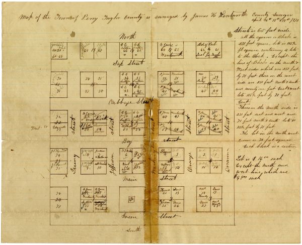
Plat of Perry, Florida, hand-drawn by James Hamilton Wentworth at the direction of the Taylor County Board of Commissioners in April 1870. The map shows lot and block numbers, street names, and the names of the owners of many of the lots. Additional information about the dimensions of the lots is provided in notes to the right of the map.
The State Archives holds a high-resolution digital copy of this map; the original is held by the Taylor County Historical Society in Perry, Florida.
The State Archives holds a high-resolution digital copy of this map; the original is held by the Taylor County Historical Society in Perry, Florida.
Date
1870-04
Format
Subjects
Geographic Term
Title
Map of Perry, Florida, 1870
Subject
City planning--Maps
Land subdivision--Maps
Description
Plat of Perry, Florida, hand-drawn by James Hamilton Wentworth at the direction of the Taylor County Board of Commissioners in April 1870. The map shows lot and block numbers, street names, and the names of the owners of many of the lots. Additional information about the dimensions of the lots is provided in notes to the right of the map.
The State Archives holds a high-resolution digital copy of this map; the original is held by the Taylor County Historical Society in Perry, Florida.
The State Archives holds a high-resolution digital copy of this map; the original is held by the Taylor County Historical Society in Perry, Florida.
Creator
Wentworth, James Hamilton (1836-1893)
Source
State Archives of Florida, Collection N2018-16
Date
1870-04
Format
maps
Language
eng-US
Type
Text
Identifier
n2018-16_01
Coverage
Late 19th-Century Florida (1877-1900)
Geographic Term
Taylor County (Fla.)
Perry (Fla.)
Thumbnail
/FMP/selected_documents/thumbnails/n2018-16_01.jpg
ImageID
n2018-16_01_01
topic
Land Sales and Development
Subject - Corporate
Board of County Commissioners (Taylor County, Fla.)
Chicago Manual of Style
Wentworth, James Hamilton (1836-1893). Map of Perry, Florida, 1870. 1870-04. State Archives of Florida, Florida Memory. <https://www.floridamemory.com/items/show/335246>, accessed 12 February 2026.
MLA
Wentworth, James Hamilton (1836-1893). Map of Perry, Florida, 1870. 1870-04. State Archives of Florida, Florida Memory. Accessed 12 Feb. 2026.<https://www.floridamemory.com/items/show/335246>
AP Style Photo Citation
(State Archives of Florida/Wentworth)

 Listen: The Folk Program