Florida Memory is administered by the Florida Department of State, Division of Library and Information Services, Bureau of Archives and Records Management. The digitized records on Florida Memory come from the collections of the State Archives of Florida and the special collections of the State Library of Florida.

State Archives of Florida
- ArchivesFlorida.com
- State Archives Online Catalog
- ArchivesFlorida.com
- ArchivesFlorida.com
State Library of Florida
Related Sites
89 items found
| Identifier | Title | Type | Subject | Thumbnail | |
|---|---|---|---|---|---|
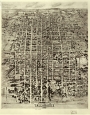
| fmc0112 | Aero-View of Tallahassee, 1926 | Tallahassee (Fla.)--Aerial views. | /FMP/maps/thumbnails/fmc0112.jpg | ||
| fmc0067 | Amelia Island Plan and Natutical Charts, 1770 | Amelia Island (Fla.)--Maps--Early works to 1800. Saint Marys River (Ga. and Fla.)--Maps--Early works to 1800. Nassau River--Maps--Early works to 1800. | /FMP/maps/thumbnails/fmc0067.jpg | ||
| fmc0177 | Amelia Island with Spanish Land Grants, 1937 | Real property--Florida--Amelia Island--Maps. Landowners--Florida--Amelia Island--Maps. Amelia Island (Fla.)--Maps. | /FMP/maps/thumbnails/fmc0177.jpg | ||
| fmc0118 | Apalachicola Bay Dredging Plan, 1890 | Channels (Hydraulic engineering)--Florida--Apalachicola Bay--Maps. Dredging--Florida--Apalachicola Bay--Maps. Nautical charts--Florida--Apalachicola Bay--Maps. Apalachicola Bay--Bathymetric maps. | /FMP/maps/thumbnails/fmc0118.jpg | ||
| fmc0227 | Apthorp's Florida, 1878 | Florida--Maps. | /FMP/maps/thumbnails/fmc0227.jpg | ||
| fmc0096 | Bird's-Eye View of Cedar-Key, Fla, 1884 | Cedar Key (Fla.)--Aerial views. | /FMP/maps/thumbnails/fmc0096.jpg | ||
| fmc0097 | Bird's-Eye View of Green Cove Springs, 1885 | Green Cove Springs (Fla.)--Aerial views. | /FMP/maps/thumbnails/fmc0097.jpg | ||
| fmc0099 | Bird's-Eye View of Jacksonville, 1876 | Jacksonville (Fla.)--Aerial views. | /FMP/maps/thumbnails/fmc0099.jpg | ||
| fmc0098 | Bird's-Eye View of Jacksonville, 1893 | Jacksonville (Fla.)--Aerial views. | /FMP/maps/thumbnails/fmc0098.jpg | ||
| fmc0101 | Bird's-Eye View of Key West, 1855 | Key West (Fla.)--Aerial views--Facsimiles. | /FMP/maps/thumbnails/fmc0101.jpg |