Florida Memory is administered by the Florida Department of State, Division of Library and Information Services, Bureau of Archives and Records Management. The digitized records on Florida Memory come from the collections of the State Archives of Florida and the special collections of the State Library of Florida.

State Archives of Florida
- ArchivesFlorida.com
- State Archives Online Catalog
- ArchivesFlorida.com
- ArchivesFlorida.com
State Library of Florida
Related Sites

Description of previous item
Description of next item

Source
Description
Date
Format
Coverage
Subjects
Geographic Term
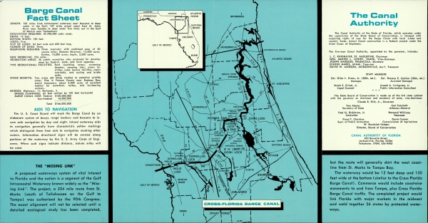
Barge Canal Fact Sheet
LENGTH: 185 miles from Intercoastal waterway near Mayport to deep water in the Gulf, 107 miles actual canal from St. Johns River near Palatka to deep water five miles out int he Gulf of Mexico, near Yankeetown.
EXCAVATION REQUIRED: 87,700,000 cubic yards.
DEPTH: 12 feet.
BOTTOM WIDTH: 150 feet.
LOCKS: Five.
SIZE OF LOCKS: 84 feet wide and 600 feet long.
NUMBER OF DAMS: Three
RESERVOIRS REQUIRED: Three reservoirs with combined area of 50 square miles; Rodman Reservoir, 13,000 acres; Eureka, 18,000 acres; Inglis, 3,500 acres.
NEW SHORELINE: 254 miles.
RECREATION AREAS: 36 public recreation sites proposed for development by Federal, state, and local agencies.
TYPE RECREATIONAL FACILITIES: Boat launching ramps, swimming beaches, camping sites, picnic facilities, some marina facilities, scenic overlooks, and cycling and bridle paths.
OTHER BENEFITS: Two areas are being studied as potential wildlife areas. One in Putnam County near Rodman Dam would encompass about 4,000 acres of excellent habitat for waterfowl, turkey, and fur-bearing animals.
BRIDGES: Highways, 11; Railroads, 3.
BRIDGE CLEARANCE: 65 feet vertical by 150 feet horizontal
BARGE CANAL COST: Federal $150,000,00
Non-Federal 16,000,000
Total $166,000,000
AIDS TO NAVIGATION
The U.S. Coast Guard will mark the Barge Canal by an elaborate system of bouys, range markers and beacons to insure safe navigation by day and night. Inland waterway aids to naviationg generally have characteristic yellow markings which distinguish them from aids to navigation marking other waters. Information directiona signs will be erected along portions of the waterway by the U.S. Army Corps of Engineers. When such signs indicate distance, statute miles will be used.
THE "MISSING LINK"
A proposed waterways system of vital interest to Florida and the nation is a segment of the Gulf Intracoastal Waterway known widely as the "Missing Link." The project, a 234 mile route from St. Marks (South of Tallahassee on the Gulf to Tapmpa) was authorized by the 90th Congress. The exact alignment will not be selected until a detailed ecological study has been completed, but the route will generally skirt the west costline from St. Marks to Tampa Bay.
The Wasterway would be 12 feet deep and 150 feet wide at the bottom (similar to the Cross Florida Barge Canal). Commerce would include coastwise movements to and from Tampa, plus Cross Florida Barge Canal traffic. The completed project would link Florida with major markets in the midwest and weld together 26 states by protected waterways.
The Canal Authority
The Canal Authority of the State of Florida, which oeprates under the supervision of the State Board of Conservation, is charged with acquiring rights fo way for the Barge Canal with local (state and county) funds. Actual Canal construction is a federal project under the Army Corps of Engineers.
The five-man Canal Authority, appointed by the governor, includes:
L.C. RINGHAVER, ST. AUGUSTINE, Chairman
GEN. SUMTER L. LOWRY, TAMPA, Vice-chairman
JOSEPH MARQUES, PENSACOLA, Secretary
EUGENCE MARKS, MIAMI, Treasurer
DAVID W. JACKSON, JACKSONVILLE, Ass't. Treasurer
STAFF MEMBERS
Col. Giles L. Evans, Jr. (USA, ret.). Manager.
Col. Thomas E Cuttino (USA, ret.) Assistant Manager
Ralph E. Elliot, Jr. Legal Counsel
Joseph A. Livingston, Jr. Public Information Consultant
The State Board of Conservation is made up of the full state cabinet with the governor as chairmand and secretary of state, vice-chairman:
Claude R. Kirk, Jr., Governor
Tom Adams Secretary of state
Earl Faircloth Attorney General
Fred O. Dickinson, Jr. Controller
Broward Williams Treasurer
Floyd T. Christian Supt. of Public Instruction
Doyle Conner Commissioner of Agriculture
W. Randolph hodges
Director, Board of Conservation
CANAL AUTHORITY OF FLORIDA
803 Rosselle Street
Jacksonville, Florida 32204
Telephone: (904) 356-0405
Title
Description
Source
Date
Format
Language
Type
Identifier
Coverage
Geographic Term
Thumbnail
Display Date
ImageID
topic
Subject - Corporate
Subject - Person
Transcript
Cross Florida Barge Canal
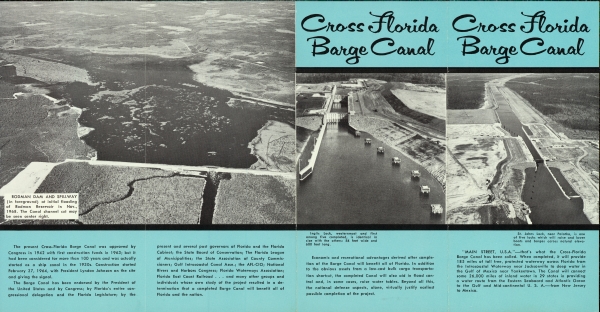
RODMAN DAM AND SPILLWAY
(in foreground) at initial flooding of Rodman Reservoir in Nov., 1968. The Cannal channel cut may be seen center right.
The present Cross-Florida Barge Cala was approved by Congress in 1942 with first construction funds in 1963, but it has been considered for more than 100 years and was actually started as a ship canal in the 1930s. Construction started February 27, 1964, with President Lyndon Johnson at the site and giving the signal.
The Barge Canal has been endorsed by the President of the United States and by congress; by Florida's entire congressional delegation and the Florida Legislature; by the present and several past governors of Florida and the Florida Cabinet; the State Board of Conservation; the Florida Leage of Municipalities; the State Assocation fo County Commissioners; Gulf Intracoastal Canal Assn.; the AFL- CIO; National Rivers and Harbors Congress; Florida Waterways Assocation; Florida East Coast Railroad... and many other groups and individuals whose own study of the project resulted in a determination that a completed Barge Canal will benefit all of Florida and the nation.
Economic and recreational advantages derviced after completion of the Barge Canal will benefit all of Florida. In addition to the obvious assets from a low-cost bulk cargo transportation shortcut, the completed Canal will also aid in flood control and, in some cases, raise water tables. Beyond all this, the national defense aspects, alone, virtually justify earliest possible completion of the project.
"MAIN STREET, U.S.A"- That's what the Cross-Florida Barge Canal ahs been called. When competed, it will provide 185 miles of toll free, protected waterway across Florida from the Intracoastal Waterway near Jacksonville to deep water in the Gulf of Mexico near Yankeetown. The Canal will connect some 26,000 miles of inland water in 29 states in providing a water route from the eastern Seaboard and Atlantic Ocean to the Gulf and Mid-continental U.S.A.- from New Jersey to Mexico.
Inglis Lock, westernmost and first among five completed, is identical in size with the others. 84 feet wide and 600 feet long.
St. Johns Lock, near Palatka, is one of five locks which will raise and lower boats and barges across natural elevation.
Barge Canal Fact Sheet
LENGTH: 185 miles from Intercoastal waterway near Mayport to deep water in the Gulf, 107 miles actual canal from St. Johns River near Palatka to deep water five miles out int he Gulf of Mexico, near Yankeetown.
EXCAVATION REQUIRED: 87,700,000 cubic yards.
DEPTH: 12 feet.
BOTTOM WIDTH: 150 feet.
LOCKS: Five.
SIZE OF LOCKS: 84 feet wide and 600 feet long.
NUMBER OF DAMS: Three
RESERVOIRS REQUIRED: Three reservoirs with combined area of 50 square miles; Rodman Reservoir, 13,000 acres; Eureka, 18,000 acres; Inglis, 3,500 acres.
NEW SHORELINE: 254 miles.
RECREATION AREAS: 36 public recreation sites proposed for development by Federal, state, and local agencies.
TYPE RECREATIONAL FACILITIES: Boat launching ramps, swimming beaches, camping sites, picnic facilities, some marina facilities, scenic overlooks, and cycling and bridle paths.
OTHER BENEFITS: Two areas are being studied as potential wildlife areas. One in Putnam County near Rodman Dam would encompass about 4,000 acres of excellent habitat for waterfowl, turkey, and fur-bearing animals.
BRIDGES: Highways, 11; Railroads, 3.
BRIDGE CLEARANCE: 65 feet vertical by 150 feet horizontal
BARGE CANAL COST: Federal $150,000,00
Non-Federal 16,000,000
Total $166,000,000
AIDS TO NAVIGATION
The U.S. Coast Guard will mark the Barge Canal by an elaborate system of bouys, range markers and beacons to insure safe navigation by day and night. Inland waterway aids to naviationg generally have characteristic yellow markings which distinguish them from aids to navigation marking other waters. Information directiona signs will be erected along portions of the waterway by the U.S. Army Corps of Engineers. When such signs indicate distance, statute miles will be used.
THE "MISSING LINK"
A proposed waterways system of vital interest to Florida and the nation is a segment of the Gulf Intracoastal Waterway known widely as the "Missing Link." The project, a 234 mile route from St. Marks (South of Tallahassee on the Gulf to Tapmpa) was authorized by the 90th Congress. The exact alignment will not be selected until a detailed ecological study has been completed, but the route will generally skirt the west costline from St. Marks to Tampa Bay.
The Wasterway would be 12 feet deep and 150 feet wide at the bottom (similar to the Cross Florida Barge Canal). Commerce would include coastwise movements to and from Tampa, plus Cross Florida Barge Canal traffic. The completed project would link Florida with major markets in the midwest and weld together 26 states by protected waterways.
The Canal Authority
The Canal Authority of the State of Florida, which oeprates under the supervision of the State Board of Conservation, is charged with acquiring rights fo way for the Barge Canal with local (state and county) funds. Actual Canal construction is a federal project under the Army Corps of Engineers.
The five-man Canal Authority, appointed by the governor, includes:
L.C. RINGHAVER, ST. AUGUSTINE, Chairman
GEN. SUMTER L. LOWRY, TAMPA, Vice-chairman
JOSEPH MARQUES, PENSACOLA, Secretary
EUGENCE MARKS, MIAMI, Treasurer
DAVID W. JACKSON, JACKSONVILLE, Ass't. Treasurer
STAFF MEMBERS
Col. Giles L. Evans, Jr. (USA, ret.). Manager.
Col. Thomas E Cuttino (USA, ret.) Assistant Manager
Ralph E. Elliot, Jr. Legal Counsel
Joseph A. Livingston, Jr. Public Information Consultant
The State Board of Conservation is made up of the full state cabinet with the governor as chairmand and secretary of state, vice-chairman:
Claude R. Kirk, Jr., Governor
Tom Adams Secretary of state
Earl Faircloth Attorney General
Fred O. Dickinson, Jr. Controller
Broward Williams Treasurer
Floyd T. Christian Supt. of Public Instruction
Doyle Conner Commissioner of Agriculture
W. Randolph hodges
Director, Board of Conservation
CANAL AUTHORITY OF FLORIDA
803 Rosselle Street
Jacksonville, Florida 32204
Telephone: (904) 356-0405
Chicago Manual of Style
Cross Florida Barge Canal - leaflet. 1969 (circa). State Archives of Florida, Florida Memory. <https://www.floridamemory.com/items/show/297493>, accessed 13 February 2026.
MLA
Cross Florida Barge Canal - leaflet. 1969 (circa). State Archives of Florida, Florida Memory. Accessed 13 Feb. 2026.<https://www.floridamemory.com/items/show/297493>
AP Style Photo Citation

 Listen: The Folk Program