Florida Memory is administered by the Florida Department of State, Division of Library and Information Services, Bureau of Archives and Records Management. The digitized records on Florida Memory come from the collections of the State Archives of Florida and the special collections of the State Library of Florida.

State Archives of Florida
- ArchivesFlorida.com
- State Archives Online Catalog
- ArchivesFlorida.com
- ArchivesFlorida.com
State Library of Florida
Related Sites

Description of previous item
Description of next item

Source
State Archives of Florida, Collection M86-38
Description
A brochure with the route and a map of the second annual Tallahassee's Live Oak Trail. Listed are significant points of interest in and around Tallahassee.
Date
1941
Publisher
Format
Topic
Subjects
Columns, The (Tallahassee, Fla.)
Federal Correctional Institution (Tallahassee, Fla.)
First Presbyterian Church (Tallahassee, Fla.)
Florida Agricultural and Mechanical University
Florida Governor's Mansion (Tallahassee, Fla.)
Florida State Capitol (Tallahassee, Fla.)
Florida State College for Women
Grove, The (Tallahassee, Fla.)
Live Oak Trail (Tallahassee, Fla.)
May Oak (Tallahassee, Fla.)
Murat, Achille, 1801-1847
Murat, Catherine Dangerfield Willis Gray, 1803-1867
Natural Bridge Battlefield (Fla.)
Old Capitol (Tallahassee, Fla.)
Tree conservation -- Florida -- Tallahassee
Trees in cities -- Florida -- Tallahassee
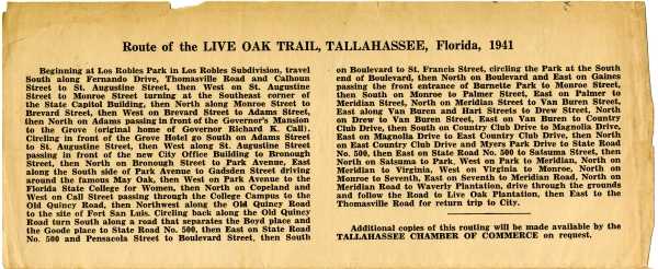
Route of the LIVE OAK TRAIL, TALLAHASSEE, Florida, 1941
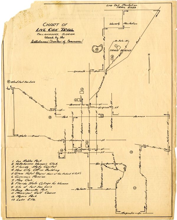
Beginning at Los Robles Park in Los Robles Subdivision, travel South along Fernando Drive, Thomasville Road and Calhoun Street to St. Augustine Street, then West on St. Augustine Street to Monroe Street turning at the Southeast corner of the State Capitol Building, then North along Monroe Street to Brevard Street, then West on Brevard Street to Adams Street, then North on Adams passing in front of the Governors's Mansion to the Grove (original home of Governor Richard K. Call). Circling in front of the Grove Hotel go South on Adams Street to St. Augustine Street, then West along along St. Augustine Street passing in front of the new City Office Building to Bronough Street, then North on Bronough Street to Park Avenue, East along the South side of Park Avenue to Gadsden Street driving around the famous May Oak, then West on Park Avenue to the Florida State College for Women, then North on Copeland and West on Call Street passing through the College Campus to Old Quincy Road, then Northwest along the Old Quincy Road to the site of Fort San Luis. Circling back along the Old Quincy Road turn South along a road that separates the Boyd place and the Goode place to State Road No. 500, then East on State Road No. 500 and Pensacola Street to Boulevard Street, then South on Boulevard to St. Francis Street, circling the park at the South end of Boulevard, then North on Boulevard and East on Gaines passing the front entrance of Burnette Park to Monroe Street, then South on Monroe to Palmer Street, East on Palmer to Meridian Street, North on Meridian Street to Van Buren Street, East along Van Buren and Hart Streets to Drew Street, North on Drew to Van Buren to Country Club Drive, then South on Country Club Drive to Magnolia Drive, East on Magnolia Drive to East Country Club Drive, then North on East Country Club Drive and Myers Park Drive to State Road No. 500, then East on State Road No. 500 to Satsuma Street, then North on Satsuma to park, West on Park to Meridian, North on Meridian to Virginia, West on Virginia to Monroe, North on Monroe to Seventh, East on Seventh to Meridian Road, North on Meridian Road to Waverly Plantation, drive through the grounds and follow the Road to Live Oak Plantation, then East to the Thomasville Road for return trip to City.
Additional copies of this routing will be made available by the TALLAHASSEE CHAMBER OF COMMERCE on request.
Title
Tallahassee's Live Oak Trail brochure, 1941
Subject
Trees in cities -- Florida -- Tallahassee
Live Oak Trail (Tallahassee, Fla.)
Tree conservation -- Florida -- Tallahassee
May Oak (Tallahassee, Fla.)
Description
A brochure with the route and a map of the second annual Tallahassee's Live Oak Trail. Listed are significant points of interest in and around Tallahassee.
Source
State Archives of Florida, Collection M86-38
Publisher
Tallahassee Chamber of Commerce
Date
1941
Format
brochures
Language
eng-US
Type
Text
Identifier
m86-38_b001_f04_01
Coverage
Florida during World War II (1939-1945)
Geographic Term
Tallahassee (Fla.)
Leon County (Fla.)
Wakulla Springs (Fla.)
Wakulla County (Fla.)
Saint Marks (Fla.)
Panacea (Fla.)
Carrabelle (Fla.)
Franklin County (Fla.)
Thumbnail
/fmp/selected_documents/thumbnails/m86-38_b001_f04_01.jpg
ImageID
m86-38_b001_f04_01_01
m86-38_b001_f04_01_02
m86-38_b001_f04_01_03
m86-38_b001_f04_01_04
topic
Tourism And Attractions
Subject - Corporate
Florida State Capitol (Tallahassee, Fla.)
Old Capitol (Tallahassee, Fla.)
Florida State College for Women
Florida Governor's Mansion (Tallahassee, Fla.)
Florida Agricultural and Mechanical University
Federal Correctional Institution (Tallahassee, Fla.)
Columns, The (Tallahassee, Fla.)
First Presbyterian Church (Tallahassee, Fla.)
Grove, The (Tallahassee, Fla.)
Natural Bridge Battlefield (Fla.)
Subject - Person
Murat, Achille, 1801-1847
Murat, Catherine Dangerfield Willis Gray, 1803-1867
Transcript
TALLAHASSEE'S
LIVE OAK TRAIL
A twenty-five mile scenic route meandering through one of the Nation's most naturally beautiful Capital Cities ...
This Map Folder is Released for your Convenience by the
TALLAHASSEE CHAMBER OF COMMERCE
Tallahassee, Florida
Route of the LIVE OAK TRAIL, TALLAHASSEE, Florida, 1941
Beginning at Los Robles Park in Los Robles Subdivision, travel South along Fernando Drive, Thomasville Road and Calhoun Street to St. Augustine Street, then West on St. Augustine Street to Monroe Street turning at the Southeast corner of the State Capitol Building, then North along Monroe Street to Brevard Street, then West on Brevard Street to Adams Street, then North on Adams passing in front of the Governors's Mansion to the Grove (original home of Governor Richard K. Call). Circling in front of the Grove Hotel go South on Adams Street to St. Augustine Street, then West along along St. Augustine Street passing in front of the new City Office Building to Bronough Street, then North on Bronough Street to Park Avenue, East along the South side of Park Avenue to Gadsden Street driving around the famous May Oak, then West on Park Avenue to the Florida State College for Women, then North on Copeland and West on Call Street passing through the College Campus to Old Quincy Road, then Northwest along the Old Quincy Road to the site of Fort San Luis. Circling back along the Old Quincy Road turn South along a road that separates the Boyd place and the Goode place to State Road No. 500, then East on State Road No. 500 and Pensacola Street to Boulevard Street, then South on Boulevard to St. Francis Street, circling the park at the South end of Boulevard, then North on Boulevard and East on Gaines passing the front entrance of Burnette Park to Monroe Street, then South on Monroe to Palmer Street, East on Palmer to Meridian Street, North on Meridian Street to Van Buren Street, East along Van Buren and Hart Streets to Drew Street, North on Drew to Van Buren to Country Club Drive, then South on Country Club Drive to Magnolia Drive, East on Magnolia Drive to East Country Club Drive, then North on East Country Club Drive and Myers Park Drive to State Road No. 500, then East on State Road No. 500 to Satsuma Street, then North on Satsuma to park, West on Park to Meridian, North on Meridian to Virginia, West on Virginia to Monroe, North on Monroe to Seventh, East on Seventh to Meridian Road, North on Meridian Road to Waverly Plantation, drive through the grounds and follow the Road to Live Oak Plantation, then East to the Thomasville Road for return trip to City.
Additional copies of this routing will be made available by the TALLAHASSEE CHAMBER OF COMMERCE on request.
[Illustrated map displaying the Live Oak Trail]
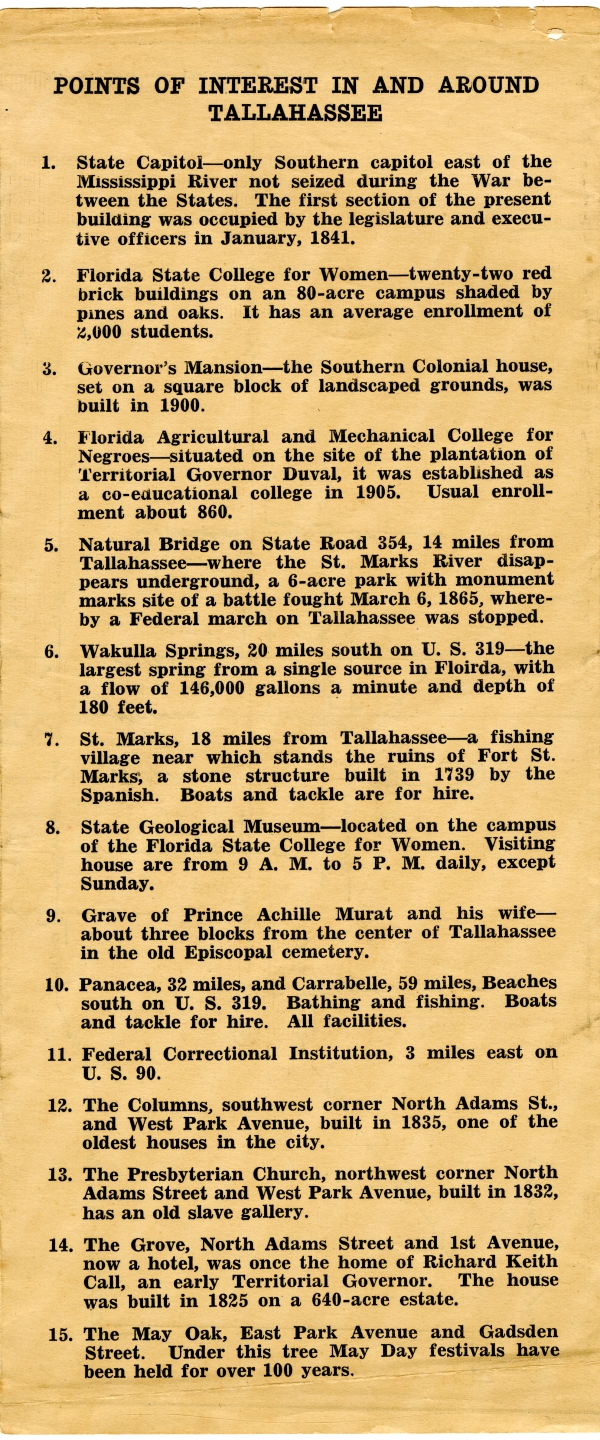
POINTS OF INTEREST IN AND AROUND Tallahassee
1. State Capitol - only Southern Capitol east of the Mississippi River not seized during the War between States. The first section of the present building was occupied by the legislature and executive officers in January 1841.
2. Florida State College for Women - twenty-two red brick buildings on an 80-acre campus shaded by pines and oaks. It has an average enrollment of 2,000 students.
3. Governor's Mansion - the Southern Colonial house, set on a square block of landscaped grounds, was built in 1900.
4. Florida Agricultural and Mechanical College for Negroes - situated on the site of the plantation of Territorial Governor Duval, it was established as a co-educational college in 1905. Usual enrollment about 860.
5. Natural Bridge on State Road 354, 14 miles from Tallahassee - where the St. marks River disappears underground, a 6-acre park with monument marks site of a battle fought March 1865, whereby a Federal march on Tallahassee was stopped.
6. Wakulla Springs, 20 miles south on U.S. 319 - the largest spring from a single source in Florida, with a flow of 146,000 gallons a minute and dept of 180 feet.
7. St. Marks, 18 miles from Tallahassee - a fishing village near which stands the ruins of Fort St. Marks, a stone structure build in 1739 by the Spanish. Boats and tackle are for hire.
8. State Geological Museum - located on the campus of the Florida State College for Women. Visiting house are from 9 A.M. to 5 P.M. daily, except Sunday.
9. Grave of Prince Achille Murat and his wife - about three blocks from the center of Tallahassee in the old Episcopal cemetery.
10. Panacea, 32 miles, and Carrabelle, 59 miles, Beaches south on U.S. 319. bathing and fishing. Boats and tackle for hire. All facilities.
11. Federal Correctional Institution, 3 miles east on U.S. 90.
12. The Columns, southwest corner North Adams St., and West Park Avenue, built in 1835, one of the oldest houses in the city.
13. The Presbyterian Church, northwest corner North Adams Street and West Park Avenue, built in 1832, has an old slave gallery.
14. The Grove, North Adams Street and 1st Avenue, now a hotel, was once the home of Richard Keith Call, an early Territorial Governor. The house was built in 1825 on a 640-acre estate.
15. The May Oak, East Park Avenue and Gadsden Street. Under this tree May Day festivals have been held for over 100 years.
Chicago Manual of Style
Tallahassee's Live Oak Trail brochure, 1941. 1941. State Archives of Florida, Florida Memory. <https://www.floridamemory.com/items/show/327570>, accessed 17 January 2026.
MLA
Tallahassee's Live Oak Trail brochure, 1941. 1941. State Archives of Florida, Florida Memory. Accessed 17 Jan. 2026.<https://www.floridamemory.com/items/show/327570>
AP Style Photo Citation

 Listen: The World Program

